The severity of the major rainfall event across Gippsland in 2021 led to a rapidly eroding gully posing a threat for the landholder, public and natural environment on a farm near Stratford. The solution was a team effort to engineer and construct a large rock chute to protect the Avon River.
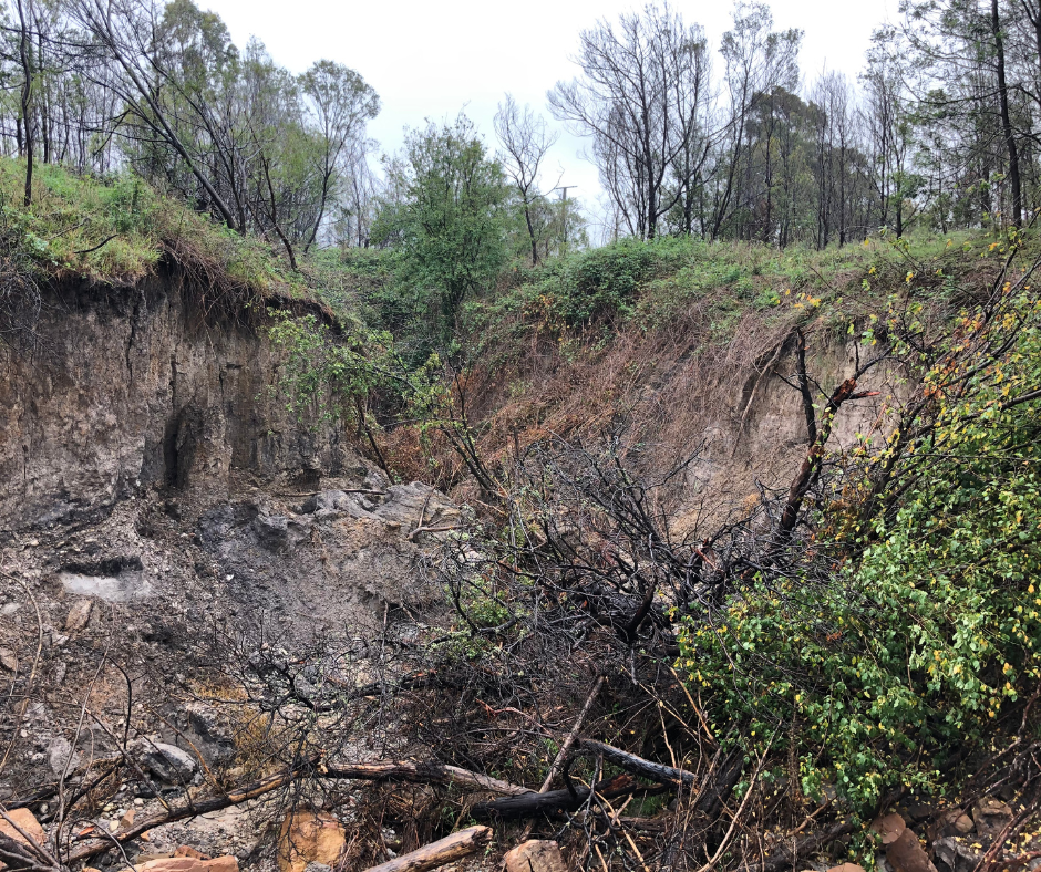
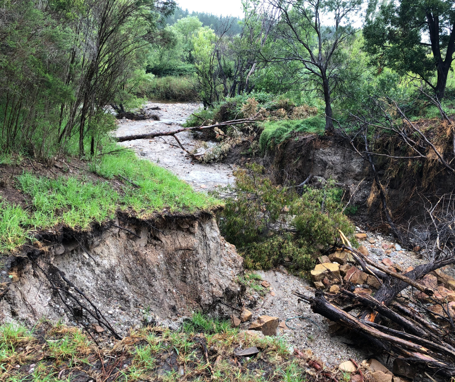
During the rainfall event, water rushed down an existing drainage line into the Avon River, damaging vegetation, dumping a huge load of sediment into the waterway and severely eroding the bank.
The resulting erosion was also rapidly progressing back up the gully and heading towards a nearby public road. This ‘upslope erosion’, known as a ’headcut‘, is often caused when water has to drop over a vertical edge to enter the river.
“In rivers with historic bed deepening (otherwise known as incision) water entering the river has to get from the level of the floodplain to the level of the river. In doing this the water expends all its kinetic (movement) energy, causing rapid erosion of the underlying soil. If you picture the power a waterfall has when it hits the bottom of its fall, it’s easy to imagine how much damage water can do when it’s falling over a vertical or near-vertical edge,” explained Elsa Burnell, West Gippsland CMA’s Project Officer.
In the Avon River system this process is exacerbated by the extremely erosive subsoils and large amount of historic deepening of the River channel that occurred in the 80s and 90s.
”The system is still adjusting to this,” said Elsa.
Without intervention the erosion would worsen with each rainfall event, causing further damage to the waterway, the surrounding property and potentially impacting the road.
“A headcut like this can easily travel 100m in one rainfall event,” said Elsa.
Elsa worked with a team from West Gippsland Catchment Management Authority and the landholders to assess the damage and develop a plan to restabilise the bank and gully to prevent further erosion.
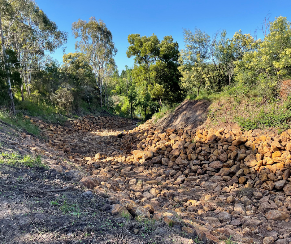
Because of the steep slope and constrained site, specialist engineers were engaged to help design a solution.
Over 1000 cubic meters of large rock was delivered to the site and placed in the eroding gully to create an armoured rock ‘chute’ The rock chute guides the water into the river and allows it to dispel its energy on a surface that is resistant to erosion.
“We needed to get the water from the higher floodplain level into the river without doing so much damage,“ Elsa said. Essentially, a rock chute allows the water to expend its energy on a surface that won’t erode.”
Protecting this gully from erosion will not only protect the road and surrounding paddocks, it will also prevent a huge amount of sediment from entering the river system and flowing on into the Gippsland Lakes.
After constructing the rock chute with machinery, the team then got to work on revegetating the surrounding area. The plants will help to protect the structure, slow future flows and further stabilise the riverbank providing resilience in future rain events.
A visit to the site two years later revealed that the rock chute and planting were holding strong and in good shape despite a number of flood events since construction. “I was really pleased to see that there was no new erosion and no sediment getting into the river,“ concluded Elsa.
Flood Recovery Program
In June 2021, widespread storm and flood damage across Gippsland impacted in many catchments.
Since then, a comprehensive flood recovery program has been rolled out across more than 150 sites in partnership with local government, agencies and landholders supported by funding from Department of Energy, Environment and Climate Action (DEECA).
Since the event, the flood recovery program delivered:
- 150 waterway structures.
- Just under 37 kilometres of fencing.
- Over 27 hectares of vegetation.
- Earthworks at 165 sites.
- 155 management agreements with landholders.